
Temperature overshoot and tipping points
Without concerted effort to reduce emissions and stop burning fossil fuels now, the world will likely overshoot 1.5°C of warming.
First described by Peruvian fishermen in the late nineteenth century as warm ocean waters around Christmas time that disrupt fishing conditions, El Niño is a natural climate phenomenon in which sea surface temperatures in the tropical Pacific are warmer than average. Under normal (or neutral) atmospheric conditions, trade winds – the east-to-west winds that blow along the earth’s equator – transport warm water from South America to Asia, which is then replaced by cooler water from lower depths. This process, referred to as upwelling, brings nutrients to the surface water, creating fertile fishing grounds. During an El Niño event, the trade winds weaken, causing warm water to accumulate in the Pacific Ocean. By contrast, when the trade winds are strong, the opposite happens and more warm water is transported to Asia – called a La Niña event. These two opposing processes – El Niño and La Niña – make up the El Niño-Southern Oscillation (ENSO) cycle.
In the past, ENSO events were described as Eastern-Pacific (EP) events, because the Eastern Pacific was where the maximum warming was located. However, the last four decades have seen an increase in the frequency of Central-Pacific (CP) events,[1]CP El Niño events are also referred to as “El Niño Modoki” and “warm pool El Niño”. where the maximum warming is located in the central equatorial Pacific. The characteristics and associated impacts of these two events differ.[2]EP ENSO has stronger El Niño events compared to La Niña events, whereas CP ENSO has stronger La Niña events compared to El Niño events.
The latest El Niño forecast, issued in June this year by the National Oceanic and Atmospheric Administration, states that El Niño has started and is expected to gradually strengthen during the Northern Hemispheric winter of 2023-2024. There is a ±56% chance of a strong El Niño and an 84% chance of a moderate El Niño. This prediction comes after an unusually long La Niña event lasting three years came to an end earlier this year. This was linked to catastrophic flooding in South-east Asia and Australia, particularly in Pakistan, where flooding displaced around eight million people, as well as the most severe drought in recent history in the Horn of Africa, which has left millions of people displaced and at risk of starvation.
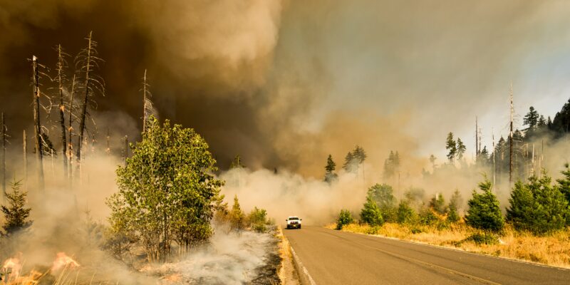
Though the effects were originally thought to be localised to the coastal regions of Peru and Ecuador, it is now known that the impacts of El Niño, as well as its cooler counterpart La Niña, are global and have been linked to crop failures, increased wildfire frequency, increased flood risk, heightened concurrent drought frequency, disruptions to fisheries, increased civil conflict and higher disease risk in various regions of the world.
The occurrence of extreme El Niño and La Niña events has increased since the 1960s, and climate projections suggest the frequency of extreme ENSO events will increase in the future.[3]The IPCC AR6 WGI report states that “a robust increase in ENSO rainfall amplitude [used for defining extreme El Niños and La Niñas] is found particularly in SSP2‑4.5, SSP3‑7.0, and … Continue reading[4]While climate models do not show consensus regarding changes in ENSO sea surface temperature variability, models that simulate extreme ENSO events do show large agreement. Some projections suggest a doubling of extreme El Niño events as global temperatures continue to rise.[5]The future period in the study included projections until 2090. CP El Niño events are expected to become more frequent with climate change, while EP events are projected to become more extreme.
During the second half of the 20th century, various changes to the behaviour of ENSO were observed, including:
As ENSO is a naturally highly variable phenomenon, determining whether the characteristics of ENSO events since the 1950s are the result of human-caused global warming, or simply a reflection of this inherent variability, is not straightforward, partly because sea surface temperature records before 1950 are sparse and unreliable.[6]In the IPCC AR6 WGI report it states that “there is medium confidence that both ENSO amplitude and the frequency of high-magnitude events since 1950 are higher than over the period from 1850 and … Continue reading Estimates using paleoclimate proxy data – which can be found in coral fossils and tree rings, for example – suggest that ENSO variability intensified by around 25% during the latter part of the 20th century compared to pre-industrial times.[7]Paleo-reconstructions typically have large uncertainty. A study published earlier this year estimates that human-caused warming has led to approximately one additional CP El Niño event and two additional extreme El Niño events since 1980. Despite the uncertainties, there is a growing consensus that human-caused warming is at least partly responsible for the changes in ENSO variability since the 1960s.
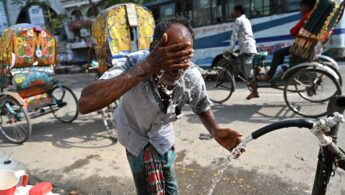
Record high sea temperatures in April this year may also worsen the upcoming El Niño event. We are likely to see record-breaking temperatures with this year’s El Niño, which is occurring against a backdrop of a warming earth – the last eight years were the world’s hottest on record. The hottest of these was in 2016 during one of the strongest El Niño events on record, which saw unparalleled coral heat stress in the world’s oceans resulting in extensive coral bleaching and die-off. ‘Pulse heat stress’ events, such as El Niño, may compound climate change-related stresses on humans and other organisms, with potentially irreversible consequences.[8]For instance, the 1982/1983 El Niño event led to the possible extinction of a coral species in Panama.
It is more likely than not that global average temperatures will temporarily exceed 1.5°C above pre-industrial levels for the first time in human history between 2023 and 2027.[9]A 66% chance of exceeding 1.5°C for one year, according to the World Meteorological Organisation’s Global Annual to Decade Climate Update. It is unlikely (33% chance) that the 5-year average … Continue reading During an extreme El Niño event, an extra 0.2°C could be added to the average temperature of the earth on top of elevated temperatures due to global warming. The first year that we see average temperatures exceed 1.5°C could be during El Niño. While this would not mean that the Paris Agreement target has been transgressed, it is a reminder that we are getting closer to this threshold.[10]Breaching the Paris Agreement target of 1.5°C of warming since pre-industrial times – a threshold seen as important for limiting the impacts of climate change on people and nature – … Continue reading
Countries and ecosystems are already experiencing climate change-induced impacts, such as heatwaves, droughts and floods, and El Niño is likely to make these impacts worse. It has also been suggested that continued global warming is making it increasingly difficult to predict El Niño events.
Predicting whether an El Niño event will occur, or how intense it will be, is challenging, mainly because predictions need to consider changes in both the Pacific Ocean and the atmosphere. While the characteristics of every El Niño event are different, our understanding of ‘teleconnections’ – whereby a climatic pattern, such as El Niño, is correlated with weather patterns elsewhere in the world – can be used to make predictions about the possible impacts. The figure below shows the typical weather impacts of El Niño across the world.
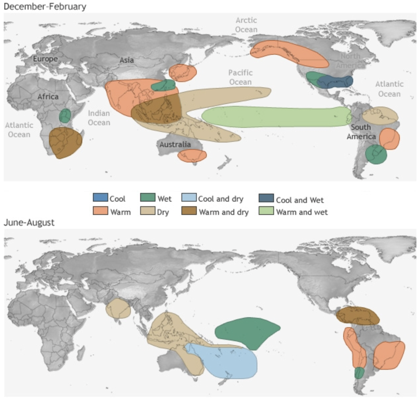
In East Africa, El Niño conditions tend to result in wetter ‘short rains’ (the second rainy season in November and December), which can cause flooding. There is also a strong link between the Indian Ocean Dipole (IOD) – the Indian Ocean counterpart of El Niño and La Niña, in which there is a difference in sea surface temperatures between the western and eastern Indian Ocean – and El Niño. When there is a positive IOD and EP El Niño, wetter short rains are amplified.
In southern Africa, drier than average conditions are expected under El Niño, resulting in decreased maize yields, while the opposite is anticipated in East Africa. In Kenya, the higher rainfall associated with the 2015-2017 El Niño cycle increased maize production by 17%, while drought conditions in southern Africa during the same period reduced maize yields by up to 50%, caused the death of around 634,000 cattle, and resulted in more than 20 million people needing humanitarian aid. By contrast, wheat yields in South Africa may benefit from El Niño.
During and after El Niño events, cholera incidence has been found to increase threefold in El Niño-sensitive areas in East Africa due to higher rainfall.
For India, El Niño tends to weaken the monsoon rains and produce drier conditions, and experts warn that when an El Niño event follows from a La Niña year – as is the case in 2023 – the monsoon rains may be particularly low.[11]Though this is dependent on various factors, such as lower Eurasian snow cover, which creates warmer conditions on the subcontinent, thereby bringing more rain to India. An assessment of rainfall trends over 132 years in India shows that severe droughts in the region have always been during El Niño years. Additionally, a CP El Niño event impacts the monsoon more than an EP event, but if an EP event occurs, there is also a higher possibility of a positive IOD occurring, which brings drier conditions to the eastern Indian Ocean (in the region of India) but wetter conditions to the western Indian Ocean (in the region of eastern Africa).
In Java, Indonesia, El Niño tends to decrease rainfall. Decreased rainfall during El Niño periods has been linked to increased forest fires in Indonesia and reduced rice yields on Java. where more than 50% of the country’s rice is grown. Fires in Indonesia are more intense and prolonged under an EP El Niño, and southern Kalimantan has experienced more intense fires than southern Sumatra under all El Niño events. However, fires are shorter and less intense during El Niño phases when the IOD is negative or weakly positive.
In the Philippines, El Niño is associated with a decrease in average rainfall and elevated drought conditions, particularly during December to May. The associated water shortages may negatively impact agricultural production in the region – the 2015/2016 El Niño event cost USD 327 million in agricultural production losses. In China, El Niño is linked to higher wintertime air pollution due to southerly winds that encourage the accumulation of particulates.
El Niño winters are associated with wetter conditions in southern Europe and colder, drier conditions in northern Europe.
In Australia, El Niño is expected to bring higher temperatures and fire risk, and lower rainfall. Australia is warming faster than some other regions on earth – being 1.4°C warmer than it was during pre-industrial times – potentially making it particularly vulnerable to the effects of El Niño.
In the Northern US and Canada, El Niño is associated with warmer conditions, whereas in the southern US and northern Mexico, wetter, cooler conditions with increased flooding risk are expected. El Niño weakens Atlantic hurricane activity but increases Pacific hurricane activity.
El Niño may reduce wheat yields in the US as well as maize yields in the southeastern US, while soybean yields may increase.
El Niño typically brings heavier rains and flooding risk to Ecuador, Peru and Uruguay, A CP El Niño brings drier conditions to the tropical Andes and northern South America, but wetter conditions to southeastern South America and the Peruvian Amazon. An EP El Niño is linked to higher rainfall in Ecuador and Peru and dry conditions in northeastern Brazil, the Amazon Basin and the Andean Plateau. Specifically, an EP El Niño is associated with reduced rainfall in northern, eastern and western Amazonia, with significant impacts on water and carbon cycling – whereby carbon atoms are cycled between the atmosphere, organisms and minerals on earth. During EP El Niño events, lower rainfall occurs across all seasons in the Amazon, turning the Amazon into a net carbon source as trees dry out and slow their growth. During CP El Niño events, reduced rainfall is only observed during the summer wet season. Increased drought may drive forest fires and biome transformation in the Amazon. Warmer, drier conditions in Colombia during El Niño have been linked to outbreaks of dengue fever and malaria.
El Niño may positively affect maize production in Argentina and Brazil, soybean and rice production in Brazil, and wheat production in Argentina due to cooler and wetter conditions. In Mexico, El Niño could reduce maize and wheat output.
References
| ↑1 | CP El Niño events are also referred to as “El Niño Modoki” and “warm pool El Niño”. |
|---|---|
| ↑2 | EP ENSO has stronger El Niño events compared to La Niña events, whereas CP ENSO has stronger La Niña events compared to El Niño events. |
| ↑3 | The IPCC AR6 WGI report states that “a robust increase in ENSO rainfall amplitude [used for defining extreme El Niños and La Niñas] is found particularly in SSP2‑4.5, SSP3‑7.0, and SSP5‑8.5… The changes in ENSO rainfall amplitude in the long-term future (2081–2100) relative to the recent past (1995–2014) are statistically significant at the 95% confidence [level]”. |
| ↑4 | While climate models do not show consensus regarding changes in ENSO sea surface temperature variability, models that simulate extreme ENSO events do show large agreement. |
| ↑5 | The future period in the study included projections until 2090. |
| ↑6 | In the IPCC AR6 WGI report it states that “there is medium confidence that both ENSO amplitude and the frequency of high-magnitude events since 1950 are higher than over the period from 1850 and possibly as far back as 1400”. |
| ↑7 | Paleo-reconstructions typically have large uncertainty. |
| ↑8 | For instance, the 1982/1983 El Niño event led to the possible extinction of a coral species in Panama. |
| ↑9 | A 66% chance of exceeding 1.5°C for one year, according to the World Meteorological Organisation’s Global Annual to Decade Climate Update. It is unlikely (33% chance) that the 5-year average temperature will remain above 1.5°C between 2023 and 2027. |
| ↑10 | Breaching the Paris Agreement target of 1.5°C of warming since pre-industrial times – a threshold seen as important for limiting the impacts of climate change on people and nature – would require several decades of average temperatures above 1.5°C. |
| ↑11 | Though this is dependent on various factors, such as lower Eurasian snow cover, which creates warmer conditions on the subcontinent, thereby bringing more rain to India. |

Without concerted effort to reduce emissions and stop burning fossil fuels now, the world will likely overshoot 1.5°C of warming.
June, July, August, September and October this year were unambiguously the hottest months since records began in the mid-1800s.